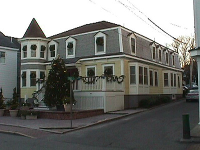
186 Commercial St
Historic District Survey information for 186 Commercial St | |
Architectural Description: 186 Commercial St. is a 2-story, 5-bay Queen Anne-style dwelling converted to commercial use; hip on mansard roof is sheathed in asphalt shingles with patterned shingles on lower mansard portion and pent eave with scroll-sawn brackets, gable dormers; exterior is clad in clapboard siding with wood corner boards and trim; building sits on a brick and concrete block foundation; fenestration includes 1/1 replacement DHS and two square bays with 1/1 DHS replacement windows on side facade; primary entrance is accessed by paired replacement doors with a metal-clad shed hood; entrance reached by wood steps and wood deck with balustrade; ramp entry to 1st-floor entrance; octagonal turret with conical roof and bracketed eave on front corner; ramp entry to basement; rear section with large commercial vents and ductwork. |
|
Historical Narrative: As per Tom Boland (1994): It is possible that the structure at 186 Commercial Street is an earlier building which was modernized in the 1880s. Early maps indicate that a structure exists there which has nearly the same footprint as the existing structure. Prior to 1880, the site was owned by G. (Gideon) Bowley and stands directly opposite J.E. & G. Bowley Wharf, also known as Steamboat Wharf (184 Commercial was owned by J.E. Bowley). In 1880, the site still has the G. Bowley name. The only subsequent change is that a porch is indicated as having been added by 1889. It is clear from a photo at the turn of the century, that the corner turret was a later addition. In 1907, the house is owned by William Matheson, who purchased the wharf and the house in 1884. Mr. Matheson managed vessels involved in the Grand Bands and West India trade.
Currently "Esther's Restaurant, Piano Bar, Guest House" and "Downstairs at Esther's" (2003). |
|
Bibliography and/or References: Barnstable County Atlas., 1880.
Barnstable County Atlas., 1907.
The Extremity of Cape Cod. Map, 1836.
H.F. Wallings Co. Map of Provincetown Village. Atlas, 1858.
Jennings, Herman A. Provincetown. Or Odds and Ends from the Tip End. 1890.
National Park Service. Salt Pond Visitor's Center Archives, Wellfleet.
Resident Directory. W.F. Richardson & Co., 1886.
Resident Directory. W.H. Hopkins, 1889. |
|
Text |
|
Commercial Street (Provincetown, Mass.), Dwellings, and Historic Districts--Massachusetts--Provincetown |
|
Comments (0)
NOTICE: It appears you do not have Javascript enabled in your Web browser. To access some of the features on the site (including email links) you must enable Javascript and refresh the page.


There are no comments for this archive.